
A FAIRLY WET & MILD SPRING EXPECTED FOR THE CENTRAL AND EASTERN U.S…
Outlook Overview
- Winter 2015-16 was yet another season of extremes, with generally well above average temperatures punctuated by a few brutal cold snaps and apocalyptic snowstorms. With the “top-three” El Niño that delivered the lower 48’s warmest winter in history weakening but still quite strong, look for April and May to yield temperature and precipitation anomalies that are only somewhat closer to climatological averages for the majority of the central and eastern U.S.
- The favored pattern based on historical analogs is a progressive jet stream over all of the lower 48, and an active subtropical jet over the eastern United States during April and May. This would generally bring somewhat above average temperatures to the western and eastern U.S. corn belt, especially north, and near normal to slightly above average temperatures to the southern tier. This general pattern also means near or below normal precipitation for the western corn belt, above average precipitation in the eastern corn belt and Mississippi Delta, and somewhat below normal rainfall for the southern Plains. A drier trend may begin zonewide towards the end of the forecast period.
General Outlook for Central and Eastern U.S. Growing Regions
The winter of 2015-2016 was again was marked by extreme weather contrasts. Temperature-wise, it’s news to no one that this winter was one of the warmest ever over much of the central and eastern U.S. region. Due to a combination of positive North Atlantic Oscillation anomalies and a very powerful El Niño, this unseasonable warmth was especially significant during a mind-bogglingly hot December, while several strong cold air outbreaks in January and February moderated the seasonal anomalies a bit. In terms of precipitation, El Niño led to brisk subtropical jet flow across the southeastern U.S., adding up to above to well above normal precipitation from the Deep South to New England. A vigorous Pacific jet also kept the Midwest wetter than average, and contributed to the powerful snowstorms seen in the mid-Atlantic, coastal Northeast, and Great Lakes. However, the Plains have turned drier in the past 30 days, while the Mississippi Delta region has seen flooding rainfall in March.

As spring bursts forth with a warm first half of March, it’s time to look ahead to April and May and take an early look at how temperature and precipitation anomalies may shape up for the corn belt, southern Plains, and Mississippi Delta growing regions. The central and eastern U.S. agricultural belts enter the planting season in fairly good shape, with the exceptions being some regions of excessive dryness in the western Plains, and recent flooding in eastern Texas, Louisiana, and southern Arkansas. In terms of global climate drivers, the vigorous El Niño that has dominated weather for the past six months continues to hang in there in the eastern Pacific after peaking a few months ago. Statistical and dynamical models are in fairly good agreement that the El Niño will continue to weaken into the summer, possibly reaching neutral levels by June or July. Some models had been showing the development of a strong La Nina over the summer and fall, but chances of this outcome are waning and a neutral-negative configuration is now more likely. Nevertheless, El Niño will continue to exercise a strong influence on global weather patterns through the end of May.
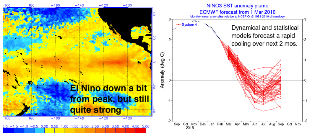
In such cases, it is instructive to take a look at some other winters that shared key characteristics with winter 2015-2016, and see what conditions in aggregate were observed in the following springs. Searching for winters that were characterized by positive El Niño and generally positive North Atlantic Oscillation index values matched 1973, 1983, 1992, and 1998. Of this set, 1983 is a particularly good match for 2016, so more weight is given to this analog in the analysis.
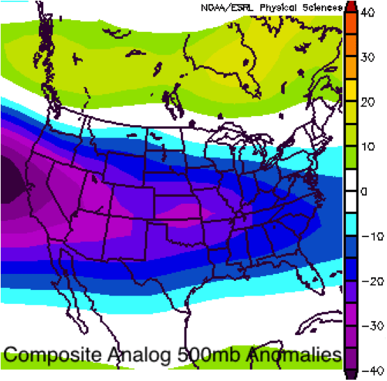 At left is the average 500mb anomaly for April and May over those analog years. Those four springs share a fairly remarkable propensity for a strongly zonal and progressive jet stream pattern over the continental U.S., with relatively small intra-set variance. This increases confidence that a similar trend will be in store for this April and May.
What does this mean in terms of temperature and precipitation relative to normal? For the most part, this means that the overall trends observed in the U.S. this winter will likely continue into spring. These trends include ample moisture surging over the southern and eastern U.S. associated with a powerful subtropical jet, and short and relatively mild cold air outbreaks. April/May average temperature anomalies are shown at left below with precipitation anomalies at right. In general, in the northern tier, the lack of troughing will likely lead to above average temperatures, with closer to average temperatures across the southern tier. Otherwise, above average precipitation will likely continue in southern and eastern sections of the forecast area, with drier conditions north and west.
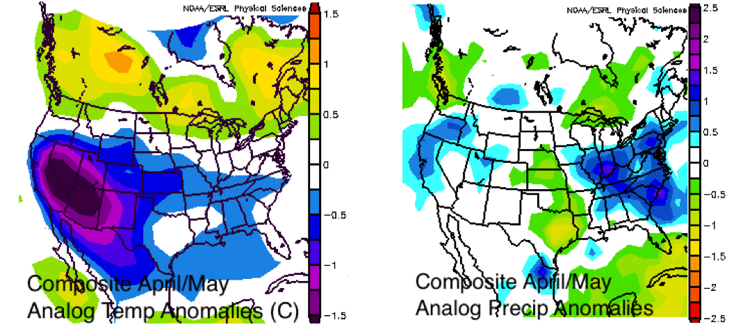
However, these data need to be adjusted to better reflect the overall pattern trends, as no historical example can fully capture natural variability or the idiosyncrasies of 2016. As the analog method is fraught with the possibility of drawing excessive conclusions from a small sample set of years, I also prepared some proprietary statistical models for April/May temperatures in the three main U.S. growing regions. The predictions of these models are blended with the pattern-based method into region-specific seasonal guidance, given below.
April/May Forecast for the Western Corn Belt including MN, ND, SD, NE, and IA
TEMPERATURES: Springs marked by transitional phases between strong El Niño and neutral or negative ENSO conditions tend to be near normal in the western corn belt. The past month has seen a positive NAO and has been quite warm and dry in the northern Plains. Persistence of recent trends and the delayed transition to weaker ENSO leads me to believe that temperatures in the western corn belt will be generally above average this April and May.
PRECIPITATION: This is a bit of a conundrum as the western belt will be in the path of Pacific moisture, but mostly miss the southern branch moisture tap. Thus, I expect near normal rainfall in the southern and eastern sections of western belt, though accumulations may be concentrated into relatively few rain events, with below average rainfall towards the Dakotas.
April/May Forecast for the Eastern Corn Belt including WS, OH, IN, IL, and MI
TEMPERATURES: Spring temperatures in the Ohio Valley also have an inverse relationship with winter NAO, but this may be tempered during excessively positive Arctic Oscillation years. With the expected zonal jet and much warmer than average Great Lakes water temperatures, look for above average temperatures in northern sections of the eastern corn belt, with near to somewhat above average temperatures in southern sections.
PRECIPITATION: All indications, including analogs and recent trends, are supportive of continued above normal precipitation this spring in the eastern corn belt, particularly southern sections.
April/May Forecast for the S. Plains/Mississippi Delta including TX, OK, AR, KS, and MO
TEMPERATURES: Per statistical modelling, factors favoring a cooler spring over the southern tier include positive ENSO and NAO values, but the same could be said of winters overall and this one was defiantly warm. Overall, there is no strong case for a forecast of anything other than near normal to slightly above average temperatures in the southern Plains and Mississippi Delta.
PRECIPITATION: Based on the expected path of the favored storm track, this region may be split between continued somewhat below normal precipitation in the southern Plains and normal to somewhat above normal rainfall in the Delta. However, there are indications that the Delta (and the east generally) may turn drier towards mid- or late May, a trend observed in the spring of 1998.