

EXPECT A FAIRLY MODERATE SPRING IN THE CENTRAL AND EASTERN U.S…
Outlook Overview
- Winter 2014-15 was a season of extremes, but this trend does not look to continue as spring begins. A very weak El Nino and the recent breakdown of formerly robust cross-polar flow are indicative of a developing pattern that will yield temperature and precipitation much closer to climatological averages in April and May for the majority of the central and eastern U.S.
- The favored pattern based on historical analogs is the tendency for a high-latitude ridge over the northern Plains and modest troughing over New England. This would generally bring near to somewhat above average temperatures to the western corn belt, near normal temperatures to the southern tier, and somewhat below normal temperatures to the eastern corn belt. This general pattern also means near normal precipitation for the western corn belt and near to slightly below normal rainfall for the southern tier and eastern corn belt.
General Outlook for Central and Eastern U.S. Growing Regions
The winter of 2014-2015 once again turned the U.S. into a country of extreme weather contrasts. Temperature-wise, it’s news to no one that this winter was one of the very coldest in history in New England and quite cold (also packing a truly impressive number of winter storms) across the southern tier and Great Lakes. Less sensationalized, however, is that the northern Plains were actually rather warm, and the west saw the warmest winter ever under robust high pressure. In terms of precipitation, a weak El Nino event led to an intermittently brisk subtropical jet flow across the southeastern U.S., adding up to at least near normal rain totals there; however, despite the snowy headlines, overall precipitation was generally below normal across the north central and northeastern U.S., outside the coastal plain. These trends are shown graphically below.
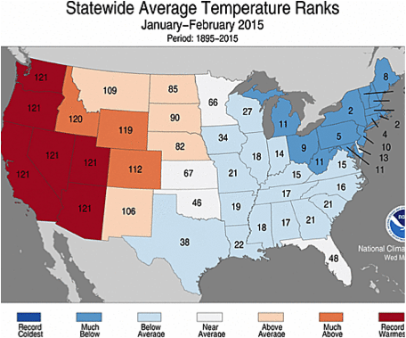
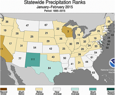
However, while eastern troughing and western ridging were extremely persistent from late December through early March, this pattern has abruptly broken down in the past 10 days with literally steamy results. Snowpack has vanished over the Plains and Great Lakes in the last week, as highs have soared into the 70s and 80s and there is currently no sign of a return to cold weather in the central and eastern U.S.
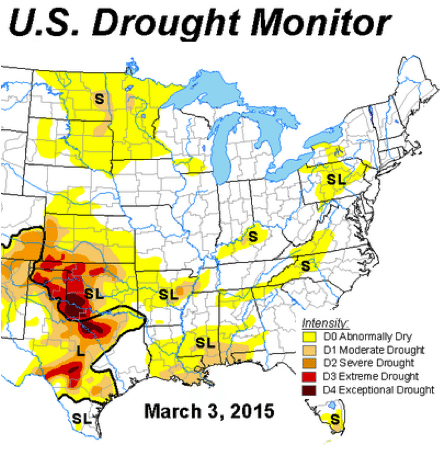
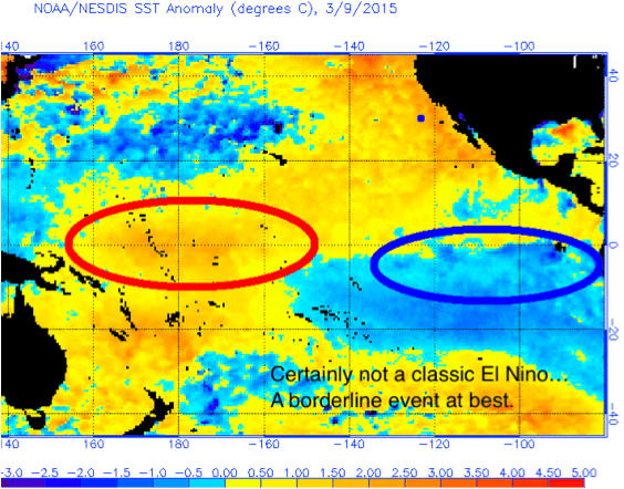
As spring boldly bursts forth, it’s time to look ahead to April and May, and take an early look at how temperature and precipitation anomalies may shape up for the corn belt, southern Plains, and Mississippi Delta growing regions. The central and eastern U.S. agricultural belts enter the season with long-term drought persisting from southwestern Kansas to northern Texas and some milder and short-term dryness in the northern Plains. In terms of global climate drivers, the vigorous El Nino that has been forecast to develop for the past year never materialized, and what we have in the Eastern Pacific at present is basically the bare minimum necessary to meet the government definition of an El Nino. (Let’s call it the ketchup-is-a-vegetable of +ENSO events.) Statistical and dynamical models are deeply split going forward, with statistical methods keying in on the cooler waters close to South America and forecasting a trend back to neutral ENSO, and dynamical forecasts locking in on the warm pool of subsurface waters and intensifying El Nino into the summer. As the dynamical models have been consistently wrong in this exact way for almost a year, I favor a weak El Nino/neutral-positive ENSO configuration for spring. This means there will not be a strong thumb on the scale for the next couple of months in the central and eastern U.S., decreasing the overall predictability of spring weather.
In such cases, it is instructive to take a look at some other winters that shared key characteristics with winter 2014-2015, and see what conditions in aggregate were observed in the following springs. Searching for winters that were characterized by weakly positive El Nino, positive Pacific-North American index values, and positive-neutral North Atlantic Oscillation index values matched 1952, 1969, 1978, and 2007. Of this set, 1978 is a particularly good match for 2015, as it also was a legendarily snowy and cold winter for the eastern U.S. and Great Lakes. Thus, more weight is given to the 1978 analog in the below analysis.
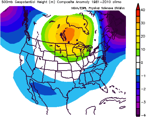 At left is the average 500mb anomaly for April and May over those analog years. Those four springs share a fairly remarkable propensity for a high-latitude blocking pattern over the Intermountain West, Canadian Prairie Provinces, and northern Plains, as troughing maintains a foothold over the northeastern U.S. In fact, March of 1978 even saw the same rapid mid-month thaw that has been observed in the central part of the country this year, before transitioning to this omega block/split flow pattern. This increases confidence that a similar trend may be in store for this April and May.
What does this mean in terms of temperature and precipitation relative to normal? For the most part, the anomalies observed in the set of analog years clung fairly closely to normal over much of the U.S. growing region in April and May despite the tendency for an amplified longwave pattern, with some exceptions. April/May average temperature anomalies are shown at left below with precipitation anomalies at right. In general, under and to the west of the mean ridging, southerly warm air advection brought warm temperatures to the Plains in these years, but also enough disturbances to keep spring rainfall near or slightly above normal. Otherwise, temperatures were cooler in the Ohio Valley and Delta closer to the influence of northeastern troughing, while a further west storm track kept these regions slightly drier than average in the analog years.
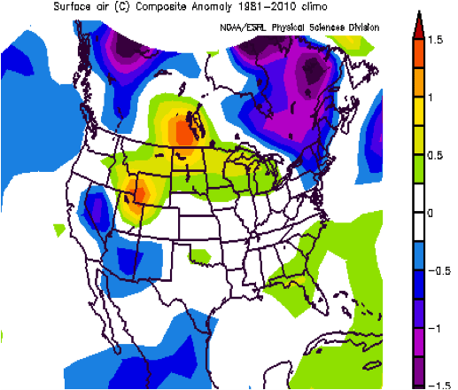
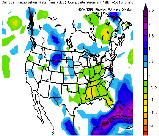
As the analog method is fraught with the possibility of drawing excessive conclusions from a small sample set of years, I also prepared some simple statistical models for April/May temperatures in the three main U.S. growing regions, using the previous winter’s temperature and precipitation and some simple climate indices like ENSO as predictors. (A similar effort for regional precipitation did not yield models with significant predictive power.) The predictions of these models are blended with the pattern-based method into region-specific seasonal guidance, given below.
April/May Forecast for the Western Corn Belt including MN, ND, SD, NE, and IA
TEMPERATURES: Winters with higher North Atlantic Oscillation (NAO) values and more precipitation tend to be followed by springs that are cooler than average in the western corn belt. The past several months saw a positive NAO but were rather dry in the northern Plains. Combined with the notable tendency for Plains high pressure in the analog years, this leads me to believe that temperatures in the western corn belt will be generally average to somewhat above average this April and May.
PRECIPITATION: West-central ridging is not necessarily negative for spring rainfall in the northern Plains, as convection often fires on the western periphery of highs. Thus, I expect near normal rainfall in the western belt, though accumulations may be concentrated into relatively few rain events.
April/May Forecast for the Eastern Corn Belt including WS, OH, IN, IL, and MI
TEMPERATURES: Spring temperatures in the Ohio Valley also have an inverse relationship with the NAO, but are less sensitive to US winter precipitation. With the expected presence of a trough over the eastern U.S. and colder than normal Great Lakes water temperatures, look for somewhat below average temperatures in the eastern corn belt, especially eastern sections.
PRECIPITATION: Should the central U.S. ridging/eastern U.S. troughing pattern materialize, the eastern corn belt will be under the influence of drier continental air masses, and can expect somewhat below normal precipitation, especially north and east.
April/May Forecast for the S. Plains/Mississippi Delta including TX, OK, AR, KS, and MO
TEMPERATURES: Per statistical modelling, factors favoring a cooler spring over the southern tier include positive ENSO and NAO values, while those favoring a warmer spring include a dry winter over the U.S. as well as a northward storm track. Overall, there is no strong case for a forecast of anything other than near normal temperatures in the southern Plains and Mississippi Delta.
PRECIPITATION: Based on the expected pattern, this region may be split between near normal precipitation in the southern Plains and slightly below normal rainfall in the Delta.