
EARLY LOOK AHEAD TO U.S. WINTER SHOWS TILT TOWARDS WARMER THAN AVERAGE TEMPERATURES IN MIDWEST, NEAR NORMAL PRECIPITATION…
Outlook Overview
- Based on summer patterns and expected conditions into the fall, winter 2017-18 in the Ohio Valley and Midwest is likely to be warmer than average. This warmth is likely to be more pronounced in the Ohio Valley than in the Upper Midwest.
- There is no consistent signal for precipitation amongst the set of analog years for the upcoming winter, with most winters in the set normal in terms of total liquid equivalent accumulation. Snow/ice expectations range from near normal in the Upper Midwest to below normal in the Ohio Valley.
General Outlook for Central U.S. Winter Temperatures and Precipitation
With August coming in cooler than average across the Midwest (so far), the fall-like weather raises the question of whether these anomalies will carry forward over the next four to six months, auguring a severe winter. This question is difficult to address in mid-August due to the long lead time and the potential for major changes in the ocean and atmosphere between now and then, but a few general trends are already emerging in the data. As always, I believe seasonal forecasting is done best, done simplest, so this look ahead at winter 2017-18 will only consider a set of variables with significant predictive power for temperature and precip in the winter ahead: El Niño state, hurricane activity, Northern Hemisphere snowpack, and fall longwave pattern. Potential trends for the winter ahead reveal themselves in these predictors.
 Starting with ENSO, the look ahead to the next six months is both a blessing and a curse for winter forecasting: there is little uncertainty in the trajectory of ENSO, but this is not helpful because we are highly confident that ENSO will not be a major player in determining U.S. winter conditions. Currently, the equatorial Pacific remains in a neutral ENSO state, showing neither a La Niña nor an El Niño pattern. Over the past month, central Pacific has joined the eastern Pacific in cooling to near or below normal. Global weather patterns in July retained a Niña-ish tilt, as they have since last winter. As seen in WeatherTiger’s August ENSO modelling at right, a neutral ENSO state is forecast through year’s end, and major changes to this overall outlook are not expected in the next 3-6 months. There are seldom large shifts in the Pacific in the latter half of the year, which is bad news as most of the skill in predicting winter conditions at a six-month lead time is derived from ENSO predictability.
The second consideration is the severity of the preceding Atlantic hurricane season. As tropical cyclones balance energy flow from the Equator to the Poles, less busy than usual Atlantic hurricane seasons usually prefigure active winters. (Think of this in terms of if “warm” doesn’t go north in the summer/fall, “cold” needs to come south in the winter.) With the busiest part of hurricane season just ahead, WeatherTiger’s final seasonal prediction for the 2017 hurricane season continues to be for above average activity in the Atlantic Basin, about 140% of the activity of a normal season. Solidly neutral El Niño conditions, warmer than average waters in key regions of the Atlantic, and weaker than average trade winds in the Caribbean over summer confirm this above-average activity signal.
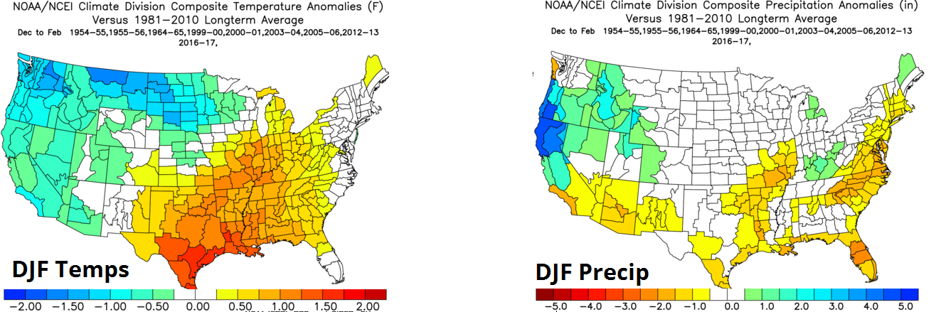
The final two predictors with some skill in predicting winter outcomes in the U.S., fall Siberian snowpack and fall U.S. longwave pattern, are unable to be used at this point due to the long lead time with this forecast. However, we will substitute the general configuration of the summer global pattern for the fall jet stream here. Together with the first two predictors, this leaves a set of eight years since 1950 which are a reasonable match for the N. Hemisphere summer pattern, and had above normal Atlantic hurricane seasons and neutral to neutral-negative winter ENSO states: 1954-55, 1955-56, 1964-65, 2000-01, 2003-04, 2005-06, 2012-13, and 2016-17. Below is the historical composite of temperature and precipitation anomalies between December and February in those years. The composite is clearly warmer than average in the eastern and southern U.S., with more normal temperatures in the Upper Midwest. In precipitation terms, the signal is less robust, but there is a tendency for drier than average conditions across the U.S. southern tier. This idea is backed by the early sense of dynamical climate models, which mostly are warmer than average across North America, without a clear signal in terms of precipitation.
Breaking it down by region, of the eight analog years, in the Ohio Valley four of them were near normal (temps)/near normal (precip), one was cooler than normal/near normal, one each were warmer than average and below, near, and above normal precip. With the forecast skewing warm and no clear precipitation signal, there is an increased risk of more than normal of this precip falling as rain in the Ohio Valley, so overall my snow/ice expectations for winter 2017-18 are below normal. In the Upper Midwest, the set of eight years includes one near normal (temps)/near normal (precip), one each of below normal temperatures and below, near, and above normal precip, and two each of above normal temperatures and near and above normal precip. Overall, temperatures skew near to slightly above normal, with precip also near to above normal. With lower rain risks here, my snow/ice expectations for the Upper Midwest is near normal accumulation this winter. Confidence is low given the 4-6 month lead, but there is enough of a signal here to be meaningful.