

WARMER BUT WETTER THAN NORMAL WINTER IN STORE FOR THE U.S SOUTH AND EAST, WHILE CENTRAL U.S. TO BE WARM AND DRY…
Outlook Overview
- Using three summer and fall datapoints (ENSO, Atlantic tropical cyclone activity, and summer longwave pattern), a first look at the severity, aggregate storm track, and snowfall anomalies for the winter of 2015-2016 is constructed.
- A strong subtropical jet undercutting high-latitude ridging is likely this winter, with generally warmer than average temperatures and less snow than normal in the north central U.S., and wetter than average conditions in the Southeast and Eastern Seaboard. These conditions are typical of strong El Nino winters.
Outlook and Discussion
“Brutal” would be an apt description for the past two winters in the central and eastern U.S. (not so in the west, where the adjective of choice would probably be “balmy” or “parched.”) The last two years have seen numerous all-time temperature and snowfall records fall, particularly in the Ohio Valley and New England, and the natural question is whether this extreme pattern will repeat for yet a third year. In general, I believe seasonal forecasting is done best when it’s simplest, so this look ahead at winter 2015-16 will only consider three variables, each with proven predictive power and a compelling physical argument for why it works: El Nino, Atlantic TC activity, and summer longwave pattern.
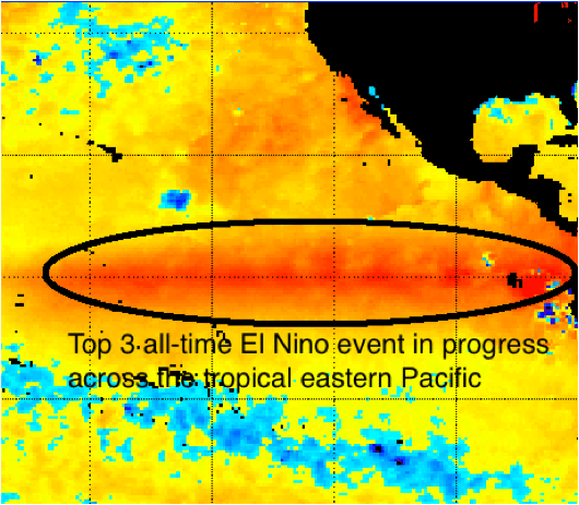 The first step is to identify cases in the historical record in which the primary driver of global weather patterns—the El Nino/Southern Oscillation, or ENSO— is a reasonable match for this year’s Pacific sea surface temperature anomalies. In 2015, this is a fairly easy exercise in pattern matching, because after a tenuous start this year’s El Nino event is one of the top three strongest events since 1950. As shown below left, the eastern Pacific is bathed in a huge swatch of +2 to +3C SST anomalies, leaving no ambiguity as to the #1 influence on the coming winter. Thus, the set of potential analog winters begins with all years in which the fall Multivariate ENSO Index topped +1.25.
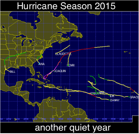 The next step is to eliminate years in which Northern Hemisphere tropical cyclone activity is not aligned with the below average hurricane counts observed in 2015 (above right). As tropical cyclones balance energy flow from the Equator to the Poles, less busy than usual Atlantic hurricane seasons usually prefigure active winters. This was the case in 2013 and 2014, when well below normal activity preceded severe U.S. winters. Finally, longwave jet patterns for the remaining potential analog years are individually compared to that observed in the summer of and fall of 2015, with poor matches thrown out. This process results in six historical years closely corresponding to 2015 conditions: 1965, 1972, 1982, 1987, 1994, and 1997. The anomalous 500mb heights are composited for early (Nov/Dec) and late winter (Jan/Feb) in these years, with heavier weightings placed on the best fits of 1982 and 1997. The results, a rough way of estimating whether winter will be colder or warmer than usual, are shown below. The same technique is also used to estimate seasonal precipitation anomalies.
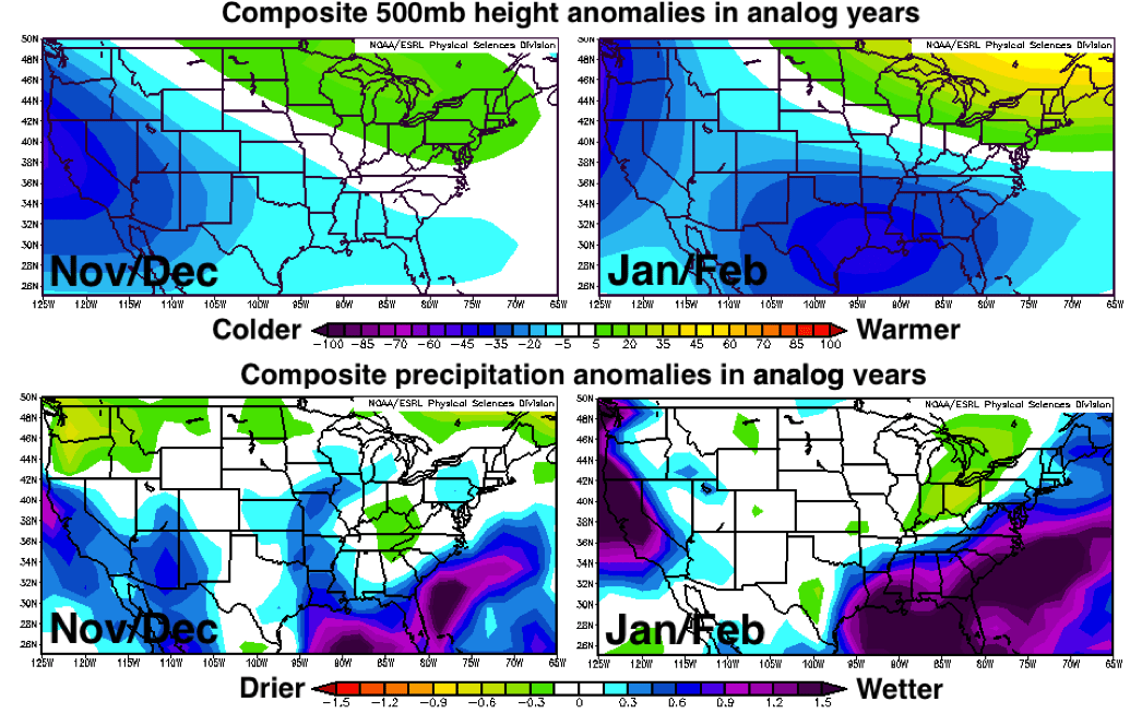
This method suggests with relatively high confidence that a powerful subtropical jet will be in place across the southern tier this winter, with numerous lows and disturbances undercutting a tendency for anomalous high-latitude ridging in eastern Canada. This pattern will likely be more pronounced in January and February, but the developing trend has already been observed in events like the recent Texas floods. In general, this means above normal temperatures are likely over the Northeast, Ohio River Valley, and Northern Plains with near normal temperatures in the forecast for the Southern Plains and Southeast. As for precipitation, the subtropical jet stream means a favored storm track from Texas to the Carolinas and riding up the Eastern Seaboard, resulting in above average chances of significant coastal lows in the mid-Atlantic and coastal New England. Conversely, drier than average conditions are anticipated inland, away from the storm track. This pattern is consistent across the early and late analog winter halves, particularly the best matches. This justifies guidance of below to well below normal snow/ice (particularly west) for the Northern Plains and Ohio Valley, near normal (inland) to somewhat above normal (coastal) snow/ice in the Northeast and well above normal precipitation with above normal chances of wintry precipitation in the Southern Plains and Southeast. In short, while the winter of 2015-16 is unlikely to touch the depth of bitter cold recorded in the past two years, look for the continuation of an active and wet pattern in the southern and eastern U.S., with warmer and drier weather expected over the center of North America.