

SUMMER LIKELY TO TURN WARMER AND DRIER THAN AVERAGE IN JULY AND AUGUST IN CENTRAL U.S., WITH WARMTH CENTERED OVER PLAINS…
Outlook Overview
- Spring 2016-17 was a season of extremes, with generally well above average precipitation for the entire U.S. ag region other than the Northern Plains. While April and May were both wet, including several significant rainstorms, April was warmer than May relative to average for most.
- A favored pattern for the summer based on historical analogs and our proprietary modeling is an increasing tendency for ridging over U.S. Southwest and Southern Plains as the season progresses. All else equal, this means a warmer and drier summer than average, particularly in the Southern Plains and western corn belt. However, with the Pacific jet likely to remain more active than normal, I believe that this tendency will be modulated wetter and milder than otherwise suggested by the analog and modeling evidence.
General Outlook for Central and Eastern U.S. Growing Regions
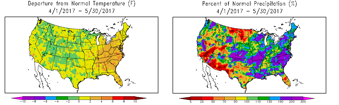
It’s been a wild spring in the corn belt and Plains, with weather running the gamut from severe flooding with repeated soaking rain events in Kansas, Missouri, the Delta, and the Ohio Valley, to extreme warmth, to freak May snowfall and strangely late freezes. In general, April was defined by eastern ridging and central U.S. troughing, with a well-worn storm track over the Plains and corn belt between them; in May, the pattern was more variable, but strongly negative North Atlantic Oscillation conditions often drove eastern troughing and associated cool and wet conditions in the ag belt. Recently, June has started out drier in the corn belt, and despite positive soil moisture anomalies, the region could still use a continuation of at least normal rainfall.
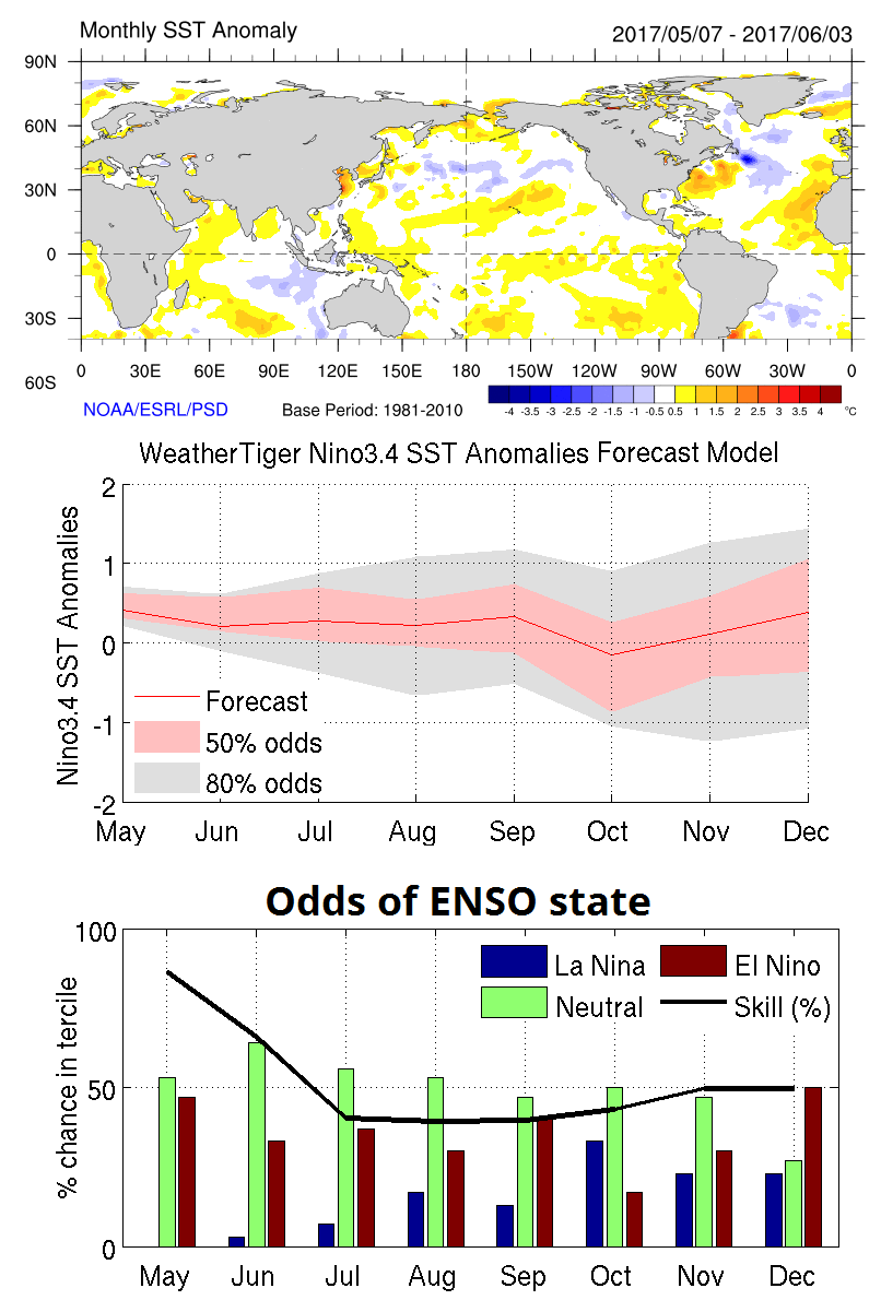
Some of the volatility in this pattern was driven not only by the amplitude of the -NAO, but also the feints towards El Niño conditions observed in the equatorial Pacific this spring. Several large drops in the Southern Oscillation Index, along with a persistently strong Pacific jet stream, preceded major periods of storminess in the central and eastern United States. This led to speculation of the development of a moderate or strong El Niño over the summer, which would have favored a cool and wet pattern for the summer over the Midwest. However, as indicated in our spring outlook, the Pacific has not continued to progress towards El Niño conditions, as shown by the near normal ocean temperatures in the eastern and central Pacific at right. Our model continues to call for neutral-positive or neutral ENSO conditions through the summer.
As even the most bullish ENSO models (like the Euro) back off on the expectation of any El Niño whatsoever, the implications for U.S. weather this summer are significant. In total, global circulation patterns remain more closely aligned with La Niña norms than El Niño patterns, albeit weakly and with much regional variation globally.
Indeed, 2017 has already proven itself unusual in that many enduring features of the past few months are not normally patterns that co-exist with one another. In searching for years that mostly closely resemble this one, our model has identified the springs most closely resembling the global patterns of rising and sinking airmasses over the past couple of months. Because of the unusual nature of 2017, the size of the analog set of years has been expanded for this summer forecast to ten years from a more typical five to better capture the range of internal variance possible over the next few months.
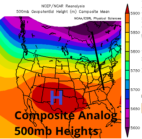
At left above is the average 500mb anomaly for meteorological summer (through August) over these ten analog years. The composite of these summers share a propensity for a jet stream located over the northern tier of the U.S., anchored by a tendency for ridging over the southwestern United States and western Plains and weak troughing over the eastern U.S. Interestingly, the strength of this anomalous ridging increases over the course of the summer, being weakest in June and strongest in August in these ten years.
What does this mean in terms of temperature and precipitation relative to normal? With a mean ridge over the Plains, look for generally warmer than average temperatures across most of the growing area, particularly in western sections, as well as closer to normal precipitation in northern and eastern sections and drier weather than average in southern and western sections.
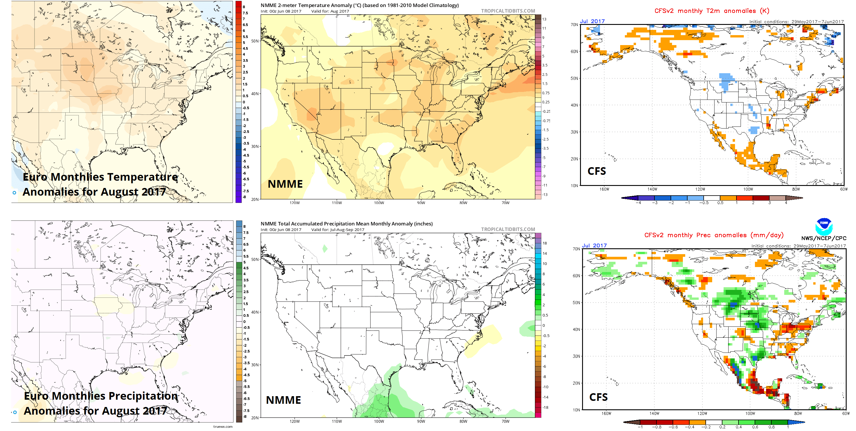
Looking at the average anomalies in the analog years by growing region, as shown below, the Southern Plains see the warmest and driest conditions relative to the long-term average. Dynamical modelling has also evolved to support this general idea, with the Euro and NMME monthlies mostly warm and dry across the U.S. in July and August. The CFS is hanging on to a cooler and wetter forecast, but it is also prone to rapid reversals and has worse long-term skill than the Euro/NMME overall. However, it did well recently in being sceptical of the purported El Niño. Interestingly, the western ridge/eastern trough idea for the summer outlook dovetails nicely with the pattern shown in medium-range modelling for the latter third of June, potentially reflecting the beginning of this shift.
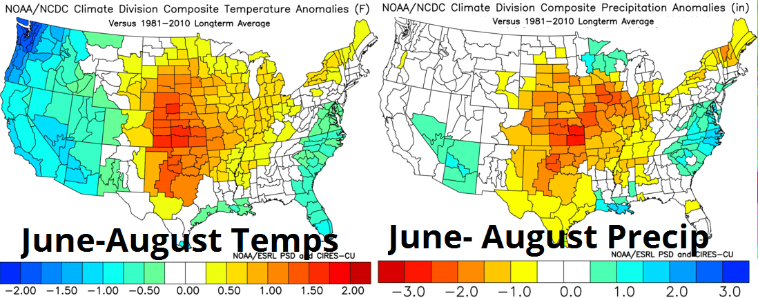
However, these data need to be adjusted to better reflect the overall pattern, as no historical example or dynamical model can fully capture natural variability or the idiosyncrasies of 2017. As the analog method is fraught with the possibility of drawing excessive conclusions from a small sample set of years, WeatherTiger’s forecast models were run for summer temps and precipitation in the three main U.S. growing regions. The predictions of these models were blended with the pattern-based method into region-specific seasonal guidance. Additionally, these outputs were modified to reflect my expectation that while the general position of the ridging/troughing may be accurate, a continued active Pacific jet will keep the pattern a little more progressive and less amplified than suggested in the analog set, blunting the extremes of heat and dryness somewhat.
Summer Forecast for the Western Corn Belt including MN, ND, SD, NE, and IA
TEMPERATURES: Summers marked by neutral or neutral-positive ENSO coupled with a mid-latitude Pacific cold pool tend to be warm in the western corn belt. May has seen the negative NAO bring cool, dry conditions to the northern Plains and western corn belt, but with the pattern gradually evolving away from that, expect somewhat above average temperatures through August.
PRECIPITATION: Look for a gradient between a wetter north and drier south/west portions of the western corn belt as the zone will be a transitional area for the favored storm path of Pacific moisture up and over the Southwest ridging. I expect a gradient from somewhat below average south/west (NE, SD), to near normal (IA, ND) to slightly above average rainfall (MN).
Summer Forecast for the Eastern Corn Belt including WS, OH, IN, IL, and MI
TEMPERATURES: With the expected progressive jet nosing down into a tendency for at least weak eastern U.S. troughing, the region will likely see near to slightly above average temperatures in north/east sections of the Ohio Valley, and slightly to somewhat above average temperatures in south/west sections.
PRECIPITATION: There is a split here been the analogs suggesting a drier pattern developing over the summer, the dynamical models showing no strong signal but skewing dry, and the subjective potential for disturbances to drop south out of the western Great Lakes and into the Ohio Valley on the northeast flank of the mean ridge. I will go with near normal precipitation here, with a drier tendency in western sections of the zone, particularly in the latter half of summer.
Summer Forecast for the S. Plains/Mississippi Delta including TX, OK, AR, KS, and MO
TEMPERATURES: The uncertainty in the forecast based on multiple lines of reasoning is probably the lowest in the Southern Plains, where the most direct impacts of Southwestern U.S. or southern tier ridging are likely to be felt even if the pattern is less amplified than advertised by the analogs. Look for somewhat above average to above average temperatures here, warmest west.
PRECIPITATION: Based on the favored storm track lying comfortably north of the southern tier, this region is likely to see somewhat below normal rainfall, particularly dry in western sections and closer to average in the Delta. These anomalies are likely to be better defined and the pattern more persistent in August. Still, I do not think there will be a severe drought, particularly given the wet spring, with enough variability in the pattern to keep the Plains from being totally shut out of rainfall this summer.
Forecaster: Dr. Ryan Truchelut (ryan@weathertiger.com)